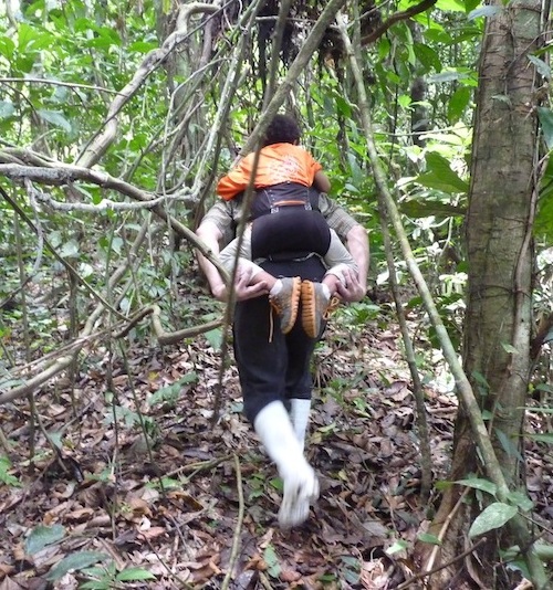
We get a late start and are ferried across the river to the search site, which is ten times larger than I expected. It is densely vegetated throughout and involves steep climbing through vines and up and down narrow ravines. Huge Ciba trees loom overhead. Our local guides wield our new machetes like pros, widening the trail admirably, but leaving the whole route at about a 5 foot height. My hat is soon an insect raft and when I take my turn carrying Ash, his hair works like fly paper. My clothes are drenched with sweat and my pure white, Michael Jackson-esque boots are caked with mud, but up we climb. Here you try not to use tree branches to help you up the slopes because they are frequently crawling with Bullet ants. These big, black ants wander everywhere with no fear. They can deliver a bite and a sting so loaded with formic acid that the pain, which lasts for 24 hours, is said to resemble being shot with a bullet. After a few hours, the team splits into two groups; one heads to the plateau where on Thomas’ satellite maps there is a clearing of sorts, the other to the site where the locals have seen stone foundations. I go with that group.
 After another hour of hiking, a very promising place is revealed to us. This area is unusually flat compared to the rest of this undulating jungle and the whole site is about the size of a small baseball field. It is split into two levels, the rear one about 15 ft higher than the front. We discover many man-made scraps of metal here, too modern for our objectives, but also we find old cement foundations. However, my experience with old houses in Seattle suggest these too are no more than a hundred years old at most. This is one of many times we feel like we are finding old rubber Baron operations left over from around the turn of the 20th century. It has already been a long day and we are too exhausted to explore this place properly, so we head down to the river to meet the rest of our team and head back to San Marjin.
That evening, by the light of flickering candles and the sounds of the jungle and Aguarunas voices behind our bamboo slat walls, we plot and scheme tomorrow’s objectives. Mostly because often, in the jungle, people re-build in places built on before, we agree that we will return to the rubber Baron site in the morning and explore it thoroughly.

 Equally at home in Peru, the mountains, or Seattle, Washington, Tammy Leland has spent the last 18 years exploring every nook and cranny of Peru’s Amazon, its Andes mountains, Southern desert and ancient history. Earning a reputation as a passionate adventurer and explorer, Tammy had wandered over 5 continents, spending her time learning from different indigenous cultures, gleaning important lessons about sustainable tourism and now offers practical guidance as a tourism consultant and environmental educator.
 Living on the edge explorer, traveler and climber, Dan Travers has traversed, climbed, scaled, scrambled, skied, trudged, trekked, hiked, biked and kayaked in 6 different continents and over 40 countries. Wilderness First Responder trained and a jungle veteran, lacrosse player, beer drinker, trekker and traveler, diver and climber, but not dancer nor singer. "I want to experience all I can, because if you are not living on the edge, you are taking up too much space."
Hello,
I supposed that you have followed Clark indications about Santiago, locating it close to the confluence of Santiago / Maranon. However, several things show it is not located here! 1st of all, its name “Santiago de Las Montanas” show it is built in a region with mountains, which is not the case where Clark located it.
In his map of 1702 Samuel Fritz, a Jesuit who has reconnoitered all the Maranon draws Santiago close to a mountain.
We find in Jimenez de la Espada “Relaciones Geograficas de Indias”, vol IV, 1897 very interesting things:
– page 36 Juan Aldrete says (in 1580) that Santiago is located some seven leagues (~35 km) from the Pongo del Manseriche.
– page 37 he says that gold is found by Indians in the rivers Cangaza and Iranbiza.
– page LXIX Juan Salinas de Loyola, the conquistador that founded Santiago, says it is built on the “barranca” of a large river that is one of the main arms of the Maranon. He adds that, at the ends of the city, has been discovered a lot of gold.
All this allows to locate it close to the confluence of the rivers Santiago and Putushin; following the Putushin to the West you reach Cangaza, at the confluence of rivers Putushin and Cangaza. Cangaza (77 48.702 W, 04 12.956 S). Supposed location of Santiago de Las Montanas (77 44.362 W, 04 14.309 S).
See Topographic map Teniente Pinglo, Peru, 1362 (9-h) J632 Edition 1-NIMA (IGN) 1999.
Best regards, M. Nallino
Thank you for sharing this information with us. When we begin the next phase of our research we will cross reference it with our information. Please stay in touch.
Hello,
No problem for sharing information!
I am currently working on the project of a book, “The Eldorado, Myths and Reality” (in French: l’Eldorado, mythes et réalités). I have accumulated interesting data (relations of the conquest of the “Pacamores” in the 16th century, withe the foundation of Santiago de las Montanas by the conquistador Juan Salinas de Loyola in 1551; the detailed result of an “inspection” done in 1580 of this region; Jesuit relations of the reductions in the Maranon, from the 17th to the 18th century, with the foundation of San Francisco de Borga in 1619 by Diego de Vaca) and maps (historical ones and modern XXth century topographic maps of this region).
You can contact me by e-mail.
In order to have an idea of my works, and if you read French, you can access from my website to a complete historical biography of Fray Marcos de Niza, a Franciscan involved in the conquest of Peru and the diiscovery of Cibola (the Zuni cities).
Regards,
M. Nallino